Conservation Easement
Morrison Property
LOCATION
Wolcott, VT
ACREAGE
241
PROTECTED SINCE
2024
CURRENT OWNERS
William Morrison
Streams, ravines, falls, and forested hillsides
The proposed Morrison easement is comprised of 282 acres in the Use Value Program, also known as Current Use (see Forest Management Map). The parcel includes:
241 acres of forest land
seven acres of wetlands
four acres of open land
a 30-acre Ecologically Significant Treatment Area (ESTA) along Wolcott Pond Brook
seasonal view of Mt. Elmore to the southwest
excellent wildlife connectivity
The Vermont Fish & Wildlife Department has established hunting rights on the central and northern areas of the property (see Morrison Easement Map). An existing four-acre homestead exclusion contains a two-story dwelling, open fields, and a pond with an earthen dam in excellent condition. An additional four-acre parcel homestead exclusion has been added south of the original homestead exclusion) for additional construction of accessory buildings related to the original homestead complex . Access to this second homestead complex is from the existing driveway. An unnamed stream flows from the dam to Wolcott Pond Brook.
The property sits within the state of Vermont's Northern Green Mountains physical region and has been designated a highest priority for overall landscape. Additional destinations include the highest ratings for connectivity blocks and riparian connectivity. The interior forest has a priority rating (VT Agency of Natural Resources, Biofinder 2024).
The Forest & Fields
Forest health is described in the ForestM anagemenPt lana s very good. There are no known threatened, rare, or endangered species on the property. Wildlife habitat is extensive, and the property contains a deer yard of approximately 200 acres. Numerous dead snags and downed woody material exist throughout the parcel with nesting cavities particularly obvious in the northern areas.
The Forest Management Map identifies 14 different stands that range from a small plot of seven acres to the largest at almost 32 acres. Forest types include:
Spruce-fir 108 acres
Mixed forest 40 acres
Northern forest 71 acres
Hemlock 7 acres
An interior road heading north is obstructed periodically by downed trees. An extensive wetland complex influenced by beaver sits to the east of this road. A hemlock stand sits amid higher-elevation ledges near the western border in Stand 3. It can also be accessed from an overgrown skid road from the homestead area. An old cellar hole exists to the east of the northern road in Stand 6. Here the land begins to rise in elevation with evidence of early farming and stone walls amid the spruce-fir forest
The land opens into a northern forest to the northern border with two pins and flagging at the northwestern corner. The forest drops down to a spruce-fir wetlands at the northeastern corner. A skid road from the wetlands leads back to the main logging road. The Forest Management Plan identifies a portion of the northern area as saw-whet owl habitat where cutting is not recommended. Nesting holes in trees appear in this area, and a barred owl, pileated woodpecker, and partridge were evident during the trustees' visit. Carpets of spring beauty (Claytonia virginica) covered the road and woods in this upland area.
The Morrison homestead is accessed along a long driveway from Pond Brook Lane off Charles Allen Road The house overlooks an artificial pond created by an earthen dam in excellent repair. The outflow stream drains to Wolcott Pond Brook. Mowed fields flank the house on three sides. This central area contains a well-maintained network of logging roads mowed annually and accessible by jeep and tractor. A circuit around the ridge behind the Morrison house allows a seasonal view of Mt. Elmore with two log landings in very good shape. Barbed wire is apparent on the western boundary.
An area of flat, formerly farmed land extends to the south from the homestead area, overgrown with spruce and balsam fir. The second homestead complex, roughly rectangular in shape, covers a portion of this area. A mowed, grassy road bisects this second complex from the open field near the house and continues southward parallel to Wolcott Pond Brook before winding west. The road ends in a drainage short of the western border.
Bill Morrison has noted a possible Continuous Forestry Inventory project in a stand of trees off the southern trail near the confluence of an unnamed stream and Wolcott Pond Brook. The project may be under the USDA Forest Service Forest Inventory & Ana!Jsis Program because the owner remembers several visits from government representatives. Confirmation could come from paperwork provided by the owner.
The southernmost area in Stands 12 and 13 is not easily accessible from the brook. No bridges currently exist. Permission from abutting landowners (Young/Romero) allows access along a woods road that crosses the Morrison southern boundary, and timber has been removed from these parcels of northern and mixed forest. The land descends sharply from flat terrain near the southern border with interior skid roads but no improved roads. The southeast corner is difficult to find about 25 yards after the land drops sharply in a northerly direction. The southwest corner was accessed from Ronald Leroux's conserved property off Town Hill Road, where Wolcott Pond Brook is apparent near the property line and continues to the Lamoille River.
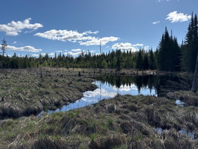
The Waterways
The property's waterways are substantial with seeps, streams, and mile-long Wolcott Pond Brook. The brook splits the parcel into a northern section with exceptional access due to improved logging roads and the roadless southern parcel where access is gained by adjacent landowner permission. The Forest Management Plan notes that Wolcott Pond Brook drains an area greater than a half square mile, requiring any crossings to comply with a Vermont 401 Water Quality Certification of US Corps of Engineers, Vermont General Permit. The brook shows signs of recent high water and some erosion with numerous downed logs and ledge outcroppings. The stream can be waded
Given the numerous small streams and the owner's participation in the state Use Value Appraisal program, the Forest Management Plan notes that the parcel is also subject to the Acceptable Management Practices for Maintaining Water Qualify on Logging Jobs in Vermont. The owner has observed these requirements by avoiding logging activities near the brook and streams. Roads are durable with effective drainage, and culverts are in good repair.
Forester Luke Hardt has identified in the Forest Management Plan an Ecologically Significant Treatment Area (ESTA) riparian buffer of 200 feet along Wolcott Pond Brook. Steep banks, some 150 feet tall, have forced storm water through the area at great velocity. No timber harvesting will happen within the ESTA area in Stand 19. Hardt notes that liver lichen (Lobaria pulmonaria) is thriving within the ESTA. The southernmost logging road runs parallel to the ESTA with a significant forest buffer.
Hardt also identifies on the forestry map the presence of state and federally significant wetlands not conducive to forestry. The northern wetlands complex that feeds the pond on the homestead exemption shows evidence of beaver, numerous waterfowl, moose, and bog vegetation such as large cranberry (Vaccinium macrocarpon) and blueberry (Vaccinium myrtilloides).